‘Willing Sellers’ sought along
Dungeness River –
Agencies work to rid river of private ownership
by Sue Forde, Editor
Citizen
Review Online
for Sierra Times
"The private
ownership status of the Dungeness River channel also makes it
difficult to implement habitat improvement or channel stabilization
projects."
- Dungeness/Quilcene Plan
Clallam County, WA - 5/8/02 - The Dungeness River is
unique in Washington State in that much of it is privately owned.
Located on the North Olympic Peninsula near Sequim, ownership runs to the middle of the river on each side. Much of the upper river (a little over 21 miles) is located
within state or federal land ownership. The lower 10.8 miles of the river, however, has historically been
held in private ownership. The will of the environmental radicals combined with federal
and state agencies is to change that in any way they can.
In 1997, the “watershed council” (which mantle
the Dungeness
River Management Team [DRMT] has taken upon itself) set up a work
group to “recommend restoration projects for the Dungeness River.” Some of the statements made in their report reflect the
underlying theme and desire to rid the river of private owners. One of
the statements they make early on reads: ““Some work will require
substantial funding, permits, property acquisition, easements or other
types of agreements with willing landowners, some of which could be
considered contentious.”
They go on to state that human activity is mostly
to blame for the demise of the fish (pink and Chinook stocks of salmon
are considered at “critical status” and “at risk of extinction.” This despite the fact that the highest number of returns of these
species were recorded this year than for many many years). The “Dungeness River floodplain has been altered by many human
activities including diking, bridge and road constrictions, removal of
log jams and large woody debris, forest and agricultural land
management, and water withdrawals,” says the working group’s
report.
In another report by county employee Joel
Freudenthal, humans were again placed second to fish, as a discussion of
the breaching of one of the dikes which protect homeowners along the
river was discussed. In his “Final Report” regarding removal of the
Kinkade Island dike, he stated, “The obvious [protecting fish]
benefits to increasing the flows within the channel had to be weighed against
an increase in flood hazard or stability of inlet channel.” The humans lost out in this one, as the dike was partially
breached, allowing water to rush toward the shorelines, undercutting the
owners’ properties. During the recent flood in January, one home was lost
entirely to the river as a result of this and the refusal to remove
large woody debris along with the refusal to allow people to protect
their homes from flooding with either sandbags or riprap.
| Rusty and Kimberly Culp stood helplessly by as the
river took their home.
Jim and Michele Connel can no longer live in their
home; the county will not allow them back into it because of the
“danger” of further flooding.
The first home in recent years to be taken by the river belonged to Glen Conley. He lost his home to the river when the Haller Dike was breached by the county, and he was told by the county that he could not keep the concrete blocks that had protected his property for years. When he finally compromised with the county and removed the
blocks, placing in their stead “riprap”, the river undercut his
home, and he lost it.
Downriver, three landowners lost much of their
property. Two are thinking
of selling now; the third stews over the potential cost to comply with
the state’s requirement for “restoration” of his property, which
involves planting hundreds of trees.
Toward the bottom of the river, at River’s End,
the county applied for and received a grant to buy out the owners there, with
plans for removing the 3.4 mile Corps of Army Engineers’ dike,
completed in 1964 for the purpose of protecting the village of
Dungeness. (Once removed,
that town will come under the flood waters again, costing private owners
there their property.)
One of the landowners at River’s End was cited in violation of the county’s critical areas ordinance, despite the fact that he proved that no harm was being done to the river, the fish or to anyone or anything. |
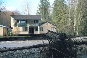 The Culp home as the creek began to rise. 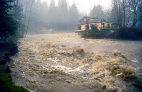 The Culp's home sits precariously atop the raging creek-turned-river after the river has eaten away the underside of the foundation.
|
||||
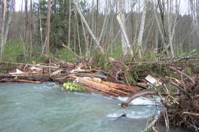
 Flood waters slam against the Kinkade Island bridge after the dike was breached to 'protect the fish.' |
He
stands to lose his property by way of a county lien – and subsequent
foreclosure on the lien – if he doesn’t comply. A “willing seller” in the making?
What has changed? Many of the owners have lived on the river for years, and have been able to protect it from the ravages of flooding. Years ago, it was not unusual to see a bulldozer in the river deepening the channel and keeping the river in its course. Just over the past few years have peoples’ property been placed in jeopardy of loss – and some, sadly, have already lost their homes. Why? What has changed? |
In early 1981, the Dungeness/Quilcene Plan was
brought about as the result of the Chelan Agreement. In it resides the foreshadowing of all that is currently taking
place. Although supposedly
sunsetted in 1995, the D/Q Plan is back and referenced quite frequently
by that same special interest group – a group that has much power over
the running of the county. (Although the DRMT itself does not have
enforcement powers, it does state that it has “implementation”
powers – and the member agencies do have – and use – their
enforcement powers – ie. State Dept. of Ecology; county Department of
Community Development).
The government dictates “no removal policies”,
which causes woody debris buildup in the river. This woody debris eventually breaks loose, causing battering and
destruction of dikes and property owners’ bank protection efforts. These current practices contrast markedly from previous
policies of removing all woody debris – in essence,
government-implemented destruction of the habitat. (Common sense and good environmental stewardship lies somewhere
between these contrary practices.)
By removing or breaching dikes that formerly
protected the private owners’ land, by leaving large woody debris in
the river instead of removing it as had been done in the past, and by
not allowing owners to protect their property with sandbags, riprap or
any other method other than “government approved, subject to
permits” ways that end up costing the property owner in both money and
loss of part or all of their property, the special interest group is
achieving its goal: to remove the ownership from private property
owners. A common theme is
to purchase the property or easements (conservation easements, usually)
from “willing sellers.”
A potential seller can become very “willing”
when the county restricts them from the ability to protect their home,
and in fact, increases the potential of danger to their home. This we have seen happening, piece by piece, along the Dungeness
River.
In 1997 after Glen Conley lost his home, a group of
approximately 70 river owners got together and formed the Dungeness
Valley Association. It disintegrated as a result of internal factions.
| In March of this year, 23 river owners and tenants
signed on to a petition to the City of Sequim demanding that the City
cable the woody debris across the channel to create a log jam (natural
dike of sorts) to help protect their property.
|
|
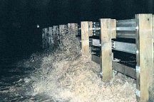
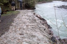
The City of Sequim's owned property gets protection from a fresh pouring of concrete. - photo by Sue Forde | ||
At present, the county’s resources far outweighs the resources of working folk in a battle over private property ownership. We’ll watch as this battle continues to unfold.
Click here for more photos of the flooding Dungeness River.